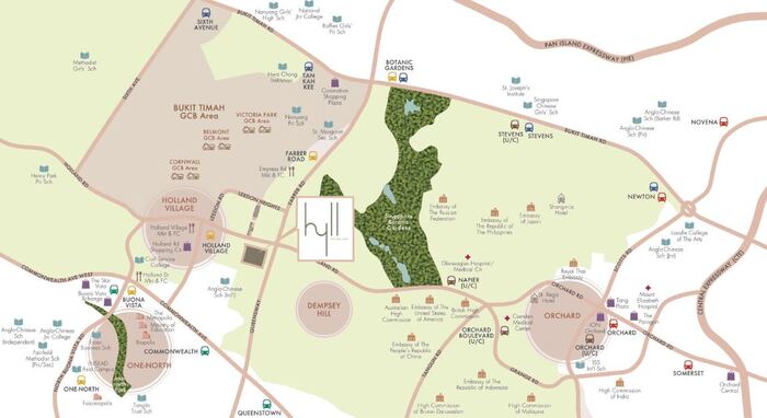
Location Map

Nearby Places

Primary Schools

  1. Nanyang Primary School (1.25 km)
  2. New Town Primary School (1.25 km)
  3. Queenstown Primary School (1.64 km)
  4. JE Educational College (2.06 km)
  5. Raffles Girls' Primary School (2.27 km)

Secondary Schools

  1. Queensway Secondary School (1.14 km)
  2. St Margaret's Secondary School (1.25 km)
  3. JE Educational College (2.06 km)
  4. Nanyang Girls' High School (2.26 km)
  5. Crescent Girls' School (2.31 km)

MRT Stations

  1. Farrer road MRT station (0.87 km)
  2. Holland village MRT station (0.9 km)
  3. Commonwealth MRT station (1.1 km)
  4. Buona vista MRT station (1.59 km)
  5. Queenstown MRT station (1.75 km)

Nearest Hospitals & Clinics

  1. OmniMed Healthcare (0.46 km)
  2. Raffles Children's Centre (0.89 km)
  3. Boey@Holland V (0.98 km)
  4. Tay Medical Centre The (1.03 km)
  5. Zimmer Pte Ltd (1.16 km)

Parks & Recreation

  1. Singapore Botanic Gardens Gallop Extension (0.92 km)
  2. Singapore Botanic Gardens (1.36 km)
  3. Coronation Park (1.53 km)
  4. one-north Park (1.73 km)
  5. Alexandra Park Connector (2.46 km)

Supermarkets

  1. Sheng Siong (1.19 km)
  2. Giant Express (1.79 km)
  3. Cold Storage @ Vista Exchange Green (1.85 km)
  4. Cold Storage @ Guthrie House (2.45 km)
  5. FairPrice Finest Artra (2.68 km)

The key advantages for Hyll On Holland is the Connectivity that surrounds the development. MRT stations such as Holland Village Road MRT, Commonwealth MRT and Buona Vista MRT surrounds the development in close proximity.

Travelling to the Central Business District area for work and entertainment in the Marina Bay area is also well supported by the Circle Line. Living near the City and also within easy access to Singapore Botanic Gardens is another beauty for Hyll On Holland.

The surrounding facilities and amenities and be explore through Hyll On Holland Location Map.